Quick Navigation
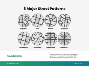
I’ve spent a lot of time thinking about how cities are laid out, and one thing that always strikes me is how much the shape of your streets determines the shape of your life. Where you can walk, how long your commute takes, whether you know your neighbors — it all traces back to decisions made by planners, sometimes hundreds of years ago. Here’s a breakdown of every major street pattern and what you actually need to know about each one.
The Organic Pattern: Beautiful Chaos
Think of Venice. Those streets didn’t come from a planning meeting — they grew over hundreds of years around waterways, bridges, and small islands. Nobody sat down and designed it. Necessity and geography did all the work, and the result is narrow winding streets that sometimes end in dead ends and sometimes open up to surprising little squares.
The charm is real. At every corner you might find a new bakery, a small shop, or an unexpected view. GPS gets confused. Tourists get lost. And somehow that’s exactly the point — there’s an escape from predictability that you just can’t manufacture.
Cities like Fez’s Medina, Istanbul’s historic districts, and Tokyo’s old neighborhoods all developed this way. People settled first, and the streets took shape around their lives. Modern urban planners are actually trying hard to preserve these patterns now, because the research is clear: organic streets support social life, strengthen neighborhood relationships, and help local businesses thrive. The downside is that infrastructure development is a nightmare. You can’t easily run water pipes and electrical cables through streets that were never designed to accommodate them.
The Grid Pattern: Simple, Powerful, Flawed
When you look at Chandigarh from the air, you see a perfect chessboard. Manhattan works on the same logic. The old New York planners said “simple is beautiful” in 1811, and they weren’t entirely wrong. Finding an address is easy. Emergency services can reach anywhere quickly because they already know the roads. Infrastructure is straightforward because everything follows the same repeatable logic.
But the grid has real problems that don’t get discussed enough. Wind corridors form between tall buildings. Every corner starts to look like the last. And geometrically, the grid quietly works against you — move one block horizontally or vertically and you’ve traveled one unit of distance, but cut diagonally and you’ve actually covered about 1.4 units. The grid looks even, but the math says otherwise. Modern grid cities try to patch this with parks, squares, and buildings of varying heights — Chicago and Barcelona being good examples of this hybrid approach.
The Radial Pattern: Everything Leads to the Center
Moscow, Paris, Washington D.C. — these cities spread outward from a central point like a star. Twelve streets radiate from the Arc de Triomphe. All roads lead to Red Square. The logic is elegant: access to the whole city flows from one important center, which stays lively and commercially vibrant because of it.
The problem is that the center becomes suffocating. Traffic congestion gets serious, and moving between neighborhoods is oddly difficult because there are often no direct connections between them. To get from point A to point B, you sometimes have to go through the center, which makes no practical sense. Most radial cities have tried to solve this with ring roads — Moscow’s MKA and Paris’s Périphérique were both built for exactly this reason.
The Irregular Pattern: Geography Wins
San Francisco’s streets climb hills, cut through grids, hit 40-degree inclines, and then level out and start gridding again. The reason is simple: when the city was founded, planners decided to ignore the topography and impose a grid anyway. The result is Lombard Street and some of the most famous car chase scenes in cinema history.
Most cities are actually irregular when you look closely. Istanbul has the Bosphorus and hills pulling everything in different directions. Rio, Hong Kong, and Seattle all have similar mixed structures — visually rich and distinctive, but genuinely hard to navigate and expensive to maintain because each neighborhood requires completely different infrastructure solutions.
The Loose Grid: The Sweet Spot
Buenos Aires has a grid, but it isn’t rigid like Chandigarh’s. Some streets are wider, some blocks are different sizes, and diagonal streets cut through to break things up and ease traffic. Melbourne uses the same system and does it really well. The city is practical without being monotonous, and there’s enough variation to carve out parks and public squares naturally.
This is honestly the pattern most urban planners quietly prefer. It’s orderly without being boring. It’s designed at a human scale. Portland, Adelaide, and Savannah all use variations of this approach, and it tends to work especially well in walkable, mild-climate cities. It’s also naturally bike-friendly in a way that strict grids rarely are.
The Suburban Pattern: Built for Cars, Not People
Auckland is almost impossible to live in without a car. That’s by design. Wide streets, large houses with gardens, curved roads with lots of dead ends — everything was built around the assumption that every family would own a car. Phoenix, Atlanta, Houston, and Las Vegas all follow this same model, and it’s entirely a product of the 1950s car boom.
The costs are real: hours in traffic, high fuel expenses, environmental pollution, and a kind of social isolation that comes from streets where you almost never run into a neighbor by accident. The benefits are also real — spacious homes, quiet streets, low crime rates, and safe space for kids to play. Modern suburbs are trying to retrofit bike lanes and public transit into all of this, but it’s genuinely hard to undo infrastructure that was built from scratch around the car.
The Superblock: Reclaiming the Street
Barcelona’s superblock experiment has gotten a lot of attention, and for good reason. Nine normal city blocks get combined into one giant superblock. Cars are gone from the interior. Pedestrians, cyclists, and kids playing in the street take over. Old parking lots become parks and gardens. Cafes open up on what used to be through streets.
The results have been measurable — cleaner air, quieter streets, increased safety, and surprisingly, a boost for local businesses because people are more comfortable spending time outside. Copenhagen and Ghent are running similar experiments with similarly positive results. The main criticism is that surrounding roads absorb more traffic, which is a legitimate concern. When Barcelona first rolled it out, the backlash was significant. But the data won people over. Paris’s 15-minute city concept follows the same underlying logic — meet all your daily needs without long-distance travel — and it’s becoming one of the more serious tools cities have for fighting car dependence and climate change.
The Linear City: The Wildcard
Saudi Arabia’s NEOM project — called The Line — is a straight city 170 kilometers long designed to hold 9 million people. It sounds like science fiction, but the linear city concept actually dates back to the 1800s, when Spanish architect Arturo Soria y Mata first proposed it and built a small section in Madrid.
The idea is that transportation centralizes along a single corridor, land use stays minimal, and the city extends rather than sprawls. Infrastructure costs are theoretically low. But the criticisms are serious — limited escape routes in emergencies, questions about how social life actually functions when your city is a line, and real uncertainty about sunlight, wind, and air circulation if the walls are tall enough. If NEOM ever gets finished, we’ll have answers. Until then, it remains the most ambitious urban planning experiment anyone has actually tried to build.
Every street pattern is really just a different answer to the same question: how do people live together well? The honest answer is that no single pattern gets everything right — the best cities tend to borrow from several of them at once.